Showing posts with label Boston. Show all posts

Thursday, January 19, 2012

Adopt a Fire Hydrant on Google Maps


Here's a cool idea to ensure that fire hydrants remain accessible even when there is heavy snow.

Adopt-a-Hydrant lets anyone in Boston sign up to volunteer to clear a specific fire hydrant in the city when there is heavy snowfall. To adopt a fire hydrant users just need to click on its map marker and complete a short form.

On the usability front it is a bit annoying that the zoom control has been removed and that scroll-wheel zooming is also disabled on the map.

Hat-tip: Street View Funny

Monday, December 5, 2011

A Google Map of Towing Spots


More than 200,000 vehicles were towed away in Boston between April 2009 and October 2011. Boston.com has created a Google Map to show where, why and when cars were towed in the city.

A heat map of the city gives a visual guide to the towing hot-spots in Boston. Users can mouse-over the map to view the total number of tows for any location. To aid users in navigation Boston.com have added to the map the names of major stores around the city.

Tuesday, August 2, 2011

Boston's Buses Live on Google Maps


With TransitSpy you can follow Boston's MBTA buses live on Google Maps.

Using the sidebar you can select any combination of MBTA bus routes and view in real-time the position of the buses on those routes. As well as the live buses all the stops on a route are displayed on the map. If you click on a bus-stop's map marker you can see how long you will have to wait until the next bus arrives.

TransitSpy MBTA

________________

Tuesday, July 19, 2011

Boston's Elastic Boundaries on Google Maps


Like many big cities Boston has very fluid neighborhood boundaries. Two people living next door to each other can often have very different ideas of which district they live in.

To try and clear up some of the confusion around Boston's boundaries Boston.com has created a Google Map that shows the different boundaries used by the Boston Redevelopment Authority, by the police, by the city and those determined by zip code.

Using the map you can drag the map pin around to view the different district boundaries at different locations.

Exploring Boston's Tangled Boundaries

_________________

Monday, April 18, 2011

Boston Marathon Live Google Map

Runkeeper - Boston Marathon Live Map

A lot of users of Runkeeper are running today's Boston Marathon. You can follow them live on this Google Map.

The map shows the route of the marathon and thumbnail images of the runners placed at their current location. The map also includes mile markers so you can see how far the runners have left to race and an elevation chart of the route.

________________

Friday, April 15, 2011

Boston & London Marathons Mapped

In the next few days both the Boston and the London marathons will be run. If you want to check out the routes and find a good place to spectate then you should check out these Google Maps.

Virgin London Marathon Interactive Map

This year Virgin have added some new features to their Google Map of the London Marathon. You can still see the route of the marathon and view Street Views along the route but there are also now some great guides to help you watch the race.

The map now includes a time slider option that allows you to see where the wheelchair racers, the elite male & females runners and the mass race should be at different times of the day. The mile markers also contain information about what kind of entertainment you are likely to find at different locations around the route.

Via: Mapperz

Adidas: Boston Marathon in Street View

Adidas have produced a Google Maps app that lets you follow the whole of the Boston Marathon route in Street View.

The Boston Marathon Map lets you follow the route of the marathon using Google Maps Street View. You can navigate to points of interest on the marathon route and view an overlay on top of the Street View to enable you to jump forward to the next point of interest or go back to the previous POI.

The Boston Marathon app includes a Google Map of the route and a terrain chart.

Going the Distance - The Wall Street Journal

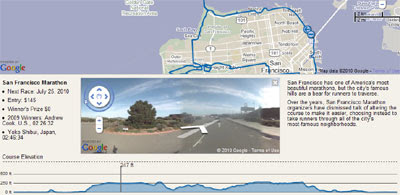
The Wall Street Journal's Going the Distance app includes Google Maps for the Boston Marathon, as well as the New York, San Francisco and Chicago marathons.

The map includes the route, an elevations chart and Street Views of the route. My favourite feature of the Wall Street Journals maps is the superb integration between the elevation chart and Street View. If you hover your mouse along the elevation chart the Street View will update to show the respective view. Very cool.

________________